Basemap
The Basemap database contains oceans, rivers, lakes, cities, highways, and political boundaries. It is updated periodically and has no expiration date.
If interested in the offer please contact with company.
Interested parties are invited to contact our company for more information about our offerings.
If interested in the offer please contact with company.
Interested parties are invited to contact our company for more information about our offerings.

TERRAIN ( TAWS )
Since the introduction of methods for determining minimum height above ground using GPWS (Ground Proximity Warning System) and TAWS (Terrain Awareness and Warning System), which are mandated by the resolution of the Chicago Convention (SARP) to be installed on all turbine-powered aircraft, and the requirements for using TAWS devices, accidents have practically dropped to zero.To develop operational principles and procedures that prevent accidents, as well as to conduct training for operational personnel that effectively reduces the risk of unintended accidents.
The functions embedded in the TAWS device create a four-dimensional position of the aircraft, which includes latitude, longitude, altitude, and time. Data is sourced from altimeters, barometers, GPS, and digital maps of the Earth.The system then compares the position of the aircraft with an onboard database containing details about terrain and obstacles.
The capabilities of TAWS are limited by the previously entered data, namely the surface map and airport database.The appropriate mode of operation for the TAWS computer analyzes situations such as approaching an obstacle (elevation) or flying at too low an altitude. In such cases, an audible alert sounds, and a voice command states: “terrain terrain – pull up, pull up,” along with additional visual warning signals saying “PULL UP.”Interested parties are invited to contact our company for more information about our offerings.
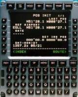
Flight Management System (FMS)
As an authorized distributor of Flight Management System (FMS) database producers, we provide updates. We have many years of experience in updating various systems, from installations on helicopters to passenger aircraft.
This specialized system, integrated with autopilot, navigation systems, and flight control systems, automates a range of tasks related to the operation and control of aircraft systems, making it a fundamental component of modern avionics.The system consists of a central Flight Management System (FMS) unit and a Flight Management Computer System (FMCS), which continuously collects information about the functioning of all systems and devices on the aircraft.
The FMCS enables real-time automatic diagnostics of the aircraft.As an onboard computer, it allows for the development of flight routes. The NavData database, which includes navigational information about airports, waypoints, and radar station frequencies, is subject to updates.
By inputting departure and arrival points along with waypoints, the system determines the flight course, allowing for fuel planning based on weight distribution.Control of radios, engines, and control surface deflections facilitates and optimizes the crew’s workload.
Access to the autopilot and connection via the aircraft’s ARINC data bus enables automatic control of flight operations set by the crew at a predetermined altitude and specified cruising speed.
The advanced FMS system also provides the capability for fully autonomous landings, which is already happening at airports of the appropriate category.Interested parties are invited to contact our company for more information about our offerings.